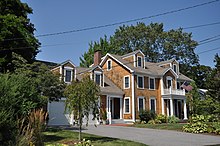
Alfred Drowne Road Historic District
Historic district in Rhode Island, United StatesThe Alfred Drowne Road Historic District of Barrington, Rhode Island, encompasses a suburban area developed between about 1860 and 1910, a period of significant suburban growth in Barrington spurred by the connection of the town by rail to Providence in 1855. This 27-acre (11 ha) residential area was before that time farmland owned by Alfred Drown, whose c. 1830 farmhouse still stands at 13 Alfred Drowne Road. The house of his son Benjamin, built c. 1856, is at number 27. The district includes properties along Alfred Drowne Road, as well as a few properties on Washington Street and Annawamscutt Road which are immediately adjacent.
Read article
Top Questions
AI generatedMore questions
Nearby Places
CVS Health Charity Classic
Golf tournament
Rhode Island Country Club

St. Andrew's School (Rhode Island)
School in Barrington, Bristol County, Rhode Island, United States

O'Bannon Mill
United States historic place

St. Matthew's Episcopal Church (Barrington, Rhode Island)
Historic church in Rhode Island, United States
Bullock's Point Light
Lighthouse
Brewer Cove Haven Marina
Marina in Rhode Island, United States

Haines Memorial State Park
State park in Bristol County, Rhode Island


